
In an unprecedented escalation, Chinese satellites are placing Souda in their sights, providing Iran with full optical access and precise coordinates of US fighter jets at 115ΠΜ.
The revelation of this digital “nakedness” turns Crete into a potential field for retaliatory strikes, irreparably exposing the strategic infrastructure of the Hellenic Air Force in the eyes of Tehran.
Satellite images of the US base at the 115 Fighter Wing in Chania have been circulating widely online in recent days, causing intense concern.
These images, originating from Chinese state and private entities, are transmitted in real time and accurately reveal the positions of US fighter aircraft on Greek soil.
According to analyses, China is acting as Iran’s “informant,” providing Tehran with the precise targeting coordinates for Souda.
This move aims to prepare Iran to unleash a possible retaliatory strike against US forces based on Crete, due to the ongoing crisis in the Middle East.
This exposure does not concern only US forces, but also renders the 115 Fighter Wing absolutely “transparent,” which hosts the most critical strike squadrons of our Hellenic Air Force, 340M and 343M.
The targeting of Greek territory is now evident and immediate
Moreover, the threat multiplies if one considers that Turkey has corresponding capabilities to receive satellite data and monitors daily all the main bases of the Hellenic Air Force.
Although the Greek side has classified countermeasures to limit the adversary’s knowledge regarding the movements of our fighters, this digital “nakedness” via third countries creates new security realities.

Sino-Iranian alliance
The provision of satellite photographs from Souda is a strategic tool within the framework of the Beijing-Tehran alliance, with China operationally strengthening Iran:
1) Intelligence exchange
China has a vast fleet of spy satellites, such as the Gaofen series. Providing high-resolution images from NATO and US bases, such as Souda, allows Iran to bypass its own technological lag and gain a real-time picture of the field.
2) Guidance systems
Iran uses the Chinese satellite navigation system BeiDou to guide its ballistic missiles and suicide drones. This makes its strikes much more accurate, as it does not depend on Western GPS, which can be disabled by the US.
3) Drone technology
Many of the components and know-how for Iranian drones, of the Shahed type, come from China. The cooperation includes the use of Chinese optical systems and sensors that allow the drones to identify targets based on the satellite data provided to them.
4) Electronic warfare
China helps Iran develop systems that can “blind” the radars of enemy bases, using surveillance data to identify the frequencies and positions of defensive systems, such as the Patriot systems at Souda.
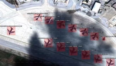
An F-15E, eleven KC-135 tankers, and two RC-135 can be seen in the Mizarvision satellite image of the Chania airport (next to the NATO Naval Support Activity, Souda Bay) in the Crete island, Greece.
— Mehdi H. (@mhmiranusa) February 20, 2026
h/t: @lobsterlarryliu pic.twitter.com/6sYHm816pA
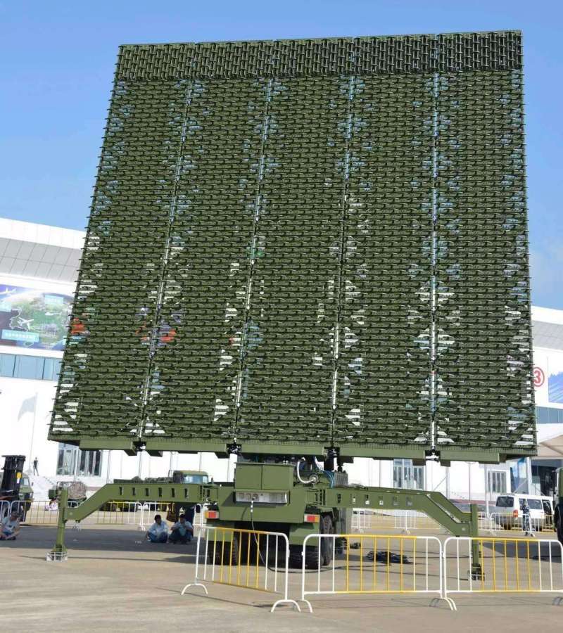
The Chinese “ghost radar” YLC-8B in Iran
In order to further fortify its airspace, Iran received the Chinese radar YLC-8B, an advanced early warning system that specializes in detecting stealth aircraft and ballistic missiles at distances approaching 700 kilometers.
This technology, based on low UHF frequencies and very rapid mobility, allows Tehran to set “traps” against ultra-modern fighters, nullifying the element of surprise for Israel and the US. Despite this strategic upgrade and support from Beijing, the viability of the system remains in question, as recent Mossad operations have proven that Iranian air defense remains vulnerable to targeted sabotage and guided strikes inside the country.
www.bankingnews.gr


Σχόλια αναγνωστών